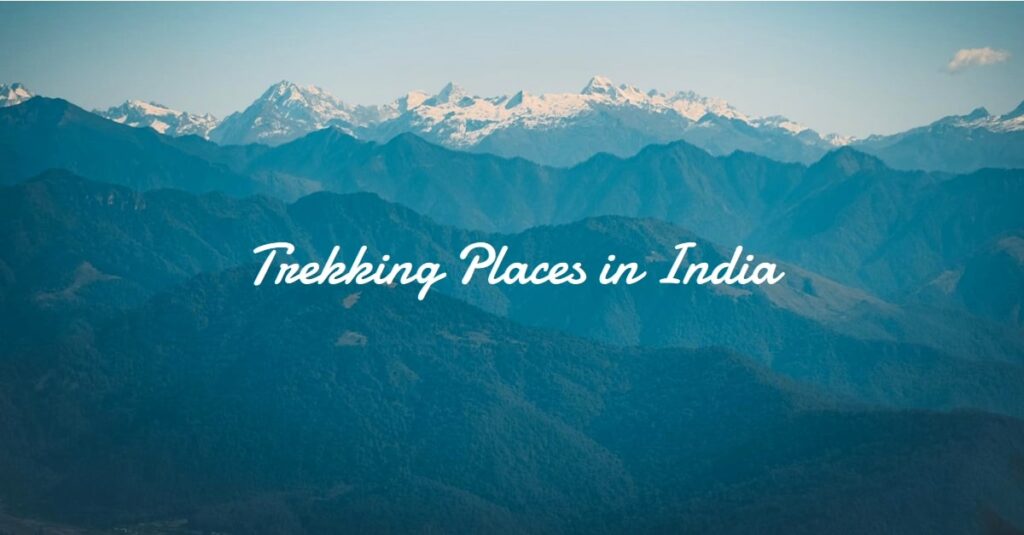
India is a country blessed with a diverse landscape, from towering mountain ranges to lush forests, and boasts about some of the top trekking places. The top 10 trekking places in India are not only a thrilling adventure but also an opportunity to explore the country’s stunning natural beauty and cultural heritage.
So, let’s dig in and get the trekking gears ready.
Step Up Your Adventure Game With Top 10 Trekking Places In India
Trekking Places In North India
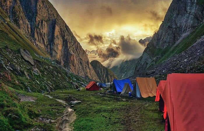
Markha Valley Trek, Kashmir
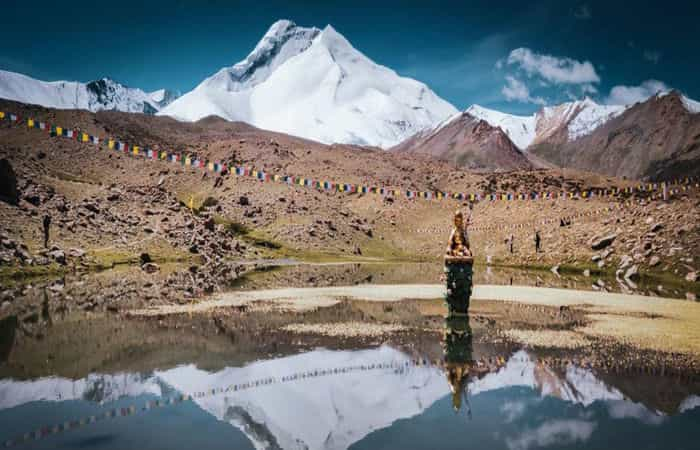
In our entry of top 10 trekking places in India, we’re starting with a big one. Located in the arid cold desert of Ladakh, Markha Valley is a breathtaking river valley nestled within Hemis National Park. Renowned for its picturesque landscapes and adventurous spirit, this trek offers an unforgettable journey.
The trek through Markha Valley entails traversing numerous river crossings, some of which are waist-deep, while also conquering the formidable Kongmaru La, a high pass standing at an impressive altitude of 17,060 feet.
Along the trail, trekkers are rewarded with awe-inspiring views of Mt Kang Yatse, a majestic peak reaching a height of 21,300 feet. Additionally, the route showcases stunning rocky canyons and abounds with diverse wildlife.
One of the most enchanting aspects of this trek is the presence of charming villages scattered throughout Markha Valley. Immerse yourself in the rich Tibetan culture thriving within these villages, where traditional ornamented kitchens and fluttering Buddhist prayer flags paint a vivid cultural tapestry.
- How to reach Markha Valley Trek? The nearest airport to Markha Valley Trek is Kushok Bakula Rimpochee Airport in Leh. From the airport, you can hire a taxi or take a bus to reach the town of Leh, which is the basecamp for the trek. From Leh, you can take a shared jeep or taxi to reach the starting point of the trek, which is the village of Spituk.
- What is Markha Valley Trek famous for? The Markha Valley Trek is famous for its rugged beauty, remote landscapes, and unique cultural experiences.
- Best time to visit Markha Valley Trek: The best time to visit Markha Valley Trek is during the months of June and September.
- What is the height of Markha Valley Trek? 5200 meters
- What is the length of Markha Valley Trek? 78 km
- How difficult is Markha Valley Trek? It is a moderate trek which takes around 7 days to complete.
Roopkund Trek, Uttarakhand
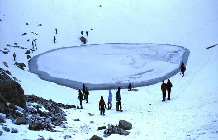
When it comes to trekking in India, the Roopkund trek is an absolute must! It offers a multitude of enticing elements that make it truly exceptional. With its deep untouched forests, babbling brooks, awe-inspiring campsites, this trek promises a thrilling adventure as you ascend from 8,000 ft to 16,000 ft over the course of six days.
Roopkund, widely regarded as one of India’s most popular treks, can be described as almost idyllic. The trail meanders through enchanting dark forests before suddenly opening up to the magnificent Ali and Bedni Bugyal, which are widely considered as the most stunning high-altitude meadows in India.
As you leave the meadows behind, the trail swiftly transitions into breathtaking alpine terrain. Ascending on snowy paths towards the Roopkund lake is an exhilarating and heart-pounding experience.
The magnificent Mt Trishul dominates the landscape, becoming increasingly closer as you climb higher. Upon reaching a ridge above Roopkund, the trekker is left with nothing but open air separating them from the majestic presence of Mt Trishul.
- How to reach Roopkund Trek? The nearest airport to Roopkund Trek is Jolly Grant Airport in Dehradun. From the airport, you can hire a taxi or take a bus to reach the town of Kathgodam, which is the basecamp for the trek.
- What is Roopkund Trek famous for? The Roopkund Trek is famous for its mysterious and captivating glacial lake known as Roopkund Lake, also known as the Skeleton Lake.
- Best time to visit Roopkund Trek: May, June, July, August, September and October are the best months to visit Roopkund trek.
- What is the height of Roopkund Trek? 5020 meters
- What is the length of Roopkund Trek? 15 km
- How difficult is Roopkund Trek? The difficulty level of this trek is moderate which takes 8 days to complete.
Suggested reads: The Top 10 Largest Lakes In India: A Spectacular Display Of Natural Beauty
Hampta Pass Trek, Himachal Pradesh
The Hampta Pass trek takes you from the verdant regions of Kullu-Manali to the arid and bleak surroundings of Chandra Valley in Lahaul. This hike provides a one-of-a-kind experience by combining distinct landscapes and cultures.
Along the trail, you’ll traverse rocky paths, lush grasslands, rushing streams, magnificent waterfalls, hanging glaciers, and be rewarded with the sight of the stunning crescent-shaped emerald lake known as “Chandratal.”
One of the highlights of this trek is witnessing the convergence of three passes: Hampta Pass, Rohtang Pass, and Spiti, which creates a surreal experience. Additionally, you’ll have the opportunity to immerse yourself in the Buddhist culture and experience the lifestyle of the remote Himalayan villages.
The inhabitants of Sethan, who originally migrated from Tibet and Spiti Valley, have preserved their distinct culture and traditions, offering a fascinating glimpse into their way of life.
- How to reach Hampta Pass Trek? The nearest airport to Hampta Pass is Bhuntar Airport in Kullu. From the airport, you can hire a taxi or take a bus to reach Manali, which serves as the base for the trek. Manali is well-connected by road to major cities in Himachal Pradesh and nearby states. You can reach Manali by bus or private vehicle.
- What is Hampta Pass famous for? The Hampta Pass is famous for its scenic beauty and the unique transition it offers from the green landscapes of Kullu Valley to the arid landscapes of Spiti Valley in the Indian state of Himachal Pradesh.
- Best time to visit Hampta Pass Trek: The Hampta Pass trek in June is one of the best times to complete this trek.
- What is the height of Hampta Pass Trek? 4270 meters
- What is the length of Hampta Pass Trek? 35 km
- How difficult is Hampta Pass Trek? It is a moderate trek which from 6 hours to a week to complete depending on itinerary.
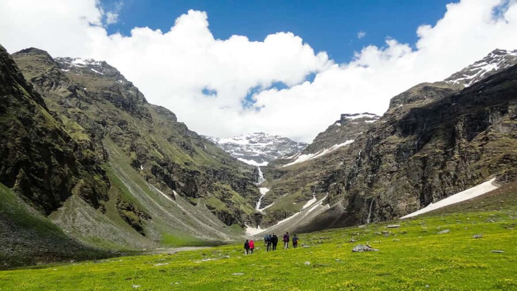
Beas Kund Trek, Himachal Pradesh
Beas Kund is a well-known trek near Manali that leads to the source of the river which flows through the town. The trek is popular among hikers due to its picturesque setting. Imagine vast green meadows thriving below the three highest mountains surrounding Manali.
In the midst of these meadows lies an emerald lake, which serves as the source of the river Beas. The contrast of this peaceful body of water tucked amidst the rugged peaks of the Pir Panjal range enhances the charm of this setting.
Standing at this spot, one can feel a sense of proximity to the origin of the roaring river visible in the valley below. The Beas Kund splits into streams and cascading waterfalls before merging with the turbulent Beas river, as is typical of every river that nourishes a civilization or settlements nearby.
The Beas Kund is also associated with a legend that the sage Rishi Vyas, who authored the Mahabharata, bathed in this lake every day. The name Beas Kund possibly originates from the combination of the sage’s name and the term “Kund,” meaning a lake.
This blend of towering snowy peaks, verdant grasslands, and the lake entices everyone to undertake this trek.
- How to reach Beas Kund Trek? The nearest airport to Valley of Flowers is Jolly Grant Airport in Dehradun. From the airport, you can hire a taxi or take a bus to reach Joshimath, which is the basecamp for the trek. From Joshimath, you can take a shared jeep or taxi to Govindghat.
- What is Beas Kund Trek famous for? The Beas Kund Trek is famous for its association with the origin of the Beas River and its stunning high-altitude glacial lake called Beas Kund.
- Best time to visit Beas Kund Trek: The best time for Beas Kund Trek is between Mid-May and Mid-October.
- What is the height of Beas Kund Trek? 3700 meters
- What is the length of Beas Kund Trek? 8 km
- How difficult is Beas Kund Trek? The Beas Kund Trek is a moderate trek.
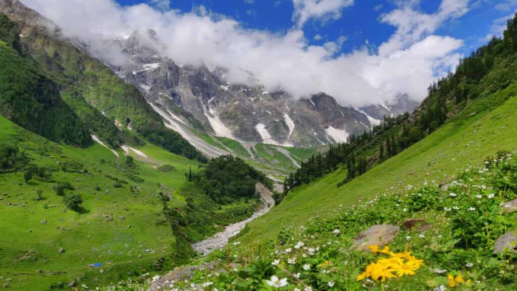
Valley of Flowers Trek, Uttarakhand
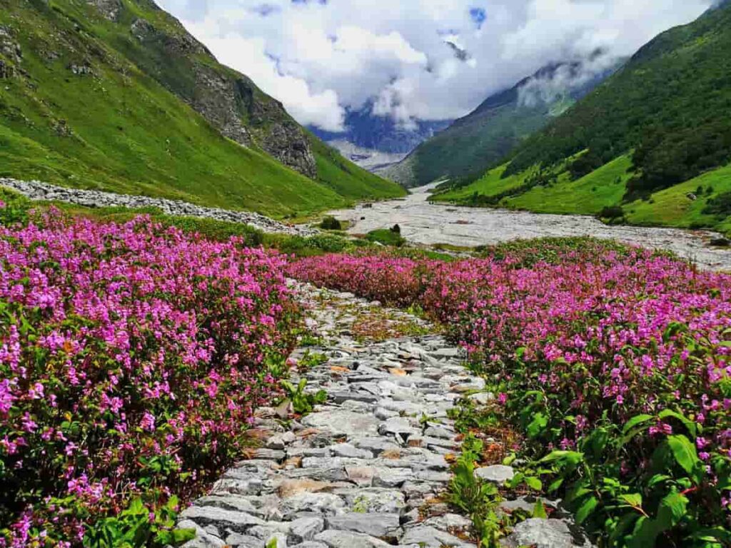
The “Foolon ki Ghati” or the Valley of Flowers is an enchanting trek that can be enjoyed during the monsoon season. This hike is located in Uttarakhand’s West Himalayan region at a high altitude of 3600 m above sea level.
The Valley of Flowers trek is renowned for providing an opportunity to witness the extremely rare blue Primula, making it one of the most famous trekking places in india and globally.
According to Hindu mythology, the Valley of Flowers is also believed to be the location where Lord Hanuman brought the magical herb to revive Lord Lakshman in the epic Ramayan.
As soon as one enters the valley, the captivating mix of aromas emitted from the flowers creates an impression of being in paradise. At an elevation of 14,400 ft, there is a concealed lake that serves as a refuge for various species of wildflowers, such as saxifrages, sedums, lilies, poppy, calendulas, daisies, geranium, zinnia, and petunia.
- How to reach Valley of Flowers Trek? The nearest airport to Beas Kund Trek is Bhuntar Airport in Kullu. From the airport, you can hire a taxi or take a bus to reach Manali, which is the basecamp for the trek. From Manali, you can take a shared jeep or taxi to reach Solang Valley
- What is Valley of Flowers Trek famous for? The Valley of Flowers Trek is famous for its exceptional natural beauty and the enchanting floral diversity it offers.
- Best time to visit Valley of Flowers Trek: August is the best time to visit the Valley of Flowers.
- What is the height of Valley of Flowers Trek? 3700 meters
- What is the length of Valley of Flowers Trek? 7 km
- How difficult is Valley of Flowers Trek? The difficulty level of the Valley of Flowers Trek is moderate, which requires you to be in good shape.
Get Exclusive Hotel Deals!

Rupin Pass Trek, Uttarakhand
The Rupin Pass trek commences from Bawta in Himachal Pradesh and concludes at Sangla, also in Himachal Pradesh, taking you through a journey of high altitudes.
This trek showcases a remarkable array of natural wonders, allowing you to witness the splendor of the majestic Himalayan ranges, cascading waterfalls, glacial meadows, snow-covered landscapes, verdant forests, picturesque hamlets, and even a unique hanging village. Nature unveils its finest creations throughout this trek.
As a high-altitude trek, Rupin Pass offers breathtaking vistas that exhilarate adventure enthusiasts. Every step of the way holds surprises, and although you may encounter steep climbs at times, the awe-inspiring views surrounding you compensate for the challenging hike.
- How to reach Rupin Pass Trek? he nearest airport to the Rupin Pass Trek is Dehradun’s Jolly Grant Airport. From the airport, you can hire a taxi or take a bus to reach Dhaula or Sewa, which are the starting points of the Rupin Pass Trek.
- What is Rupin Pass Trek famous for? The Rupin Pass Trek is famous for its awe-inspiring natural beauty and varied landscapes.
- Best time to visit Rupin Pass Trek May or June offers the most suitable climate for trekking at this place.
- What is the height of Rupin Pass Trek? 4650 meters
- What is the length of Rupin Pass Trek? 12 km
- How difficult is Rupin Pass Trek? Overall, it is a quite difficult trek to take on.
Trekking Places In West India
Rajmachi Trek, Maharashtra
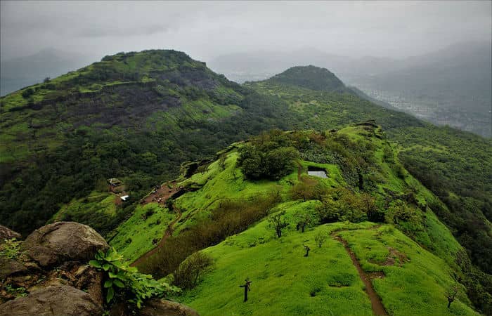
The Rajmachi Trek is situated between two renowned hill stations – Lonavala and Karjat. The trek can be accessed from either the Lonavala or Karjat side and presents the opportunity to climb two forts starting from the same base village called Udhewadi.
The Shriwardhan fort, which faces east, is located at an elevation of 2710 feet, while the west facing Manaranjan fort stands at 2510 feet. If you take the Lonavala route, the trail is longer but less challenging, and you will mostly trek through muddy trails in the forest section until you reach Udhewadi.
On the other hand, the Kandala route, which starts from the Khondane caves and waterfalls, involves a steeper climb through the forest section to reach Udhewadi.
The Satavahanas built these forts, but they gained popularity during the reign of Shivaji Maharaj, who took over the fort in the 15th century. Shivaji Maharaj reinforced and extended the fort by adding various structures within the premises.
These forts have witnessed battles between the Marathas and the Mughals and were later captured by the British in the 19th century. Additionally, the fort was once a crucial trade route connecting present-day Mumbai and Pune.
- How to reach Rajmachi Trek? The nearest airport to Rajmachi Trek is Chhatrapati Shivaji International Airport in Mumbai. From the airport, you can hire a taxi or take a bus to reach Lonavala, which is the nearest town to Rajmachi. From Lonavala, you can take a shared jeep or taxi to reach the starting point of the trek.
- What is Rajmachi Trek famous for? The Rajmachi Trek is famous for its historical and cultural significance. Situated in the Sahyadri mountain range in the Indian state of Maharashtra, the trek takes you to the twin hill forts of Shrivardhan Fort and Manoranjan Fort.
- Best time to visit Rajmachi Trek: June to February is the best time to take this trek journey.
- What is the height of Rajmachi Trek? About 1000 meters
- What is the length of Rajmachi Trek? 13 km
- How difficult is Rajmachi Trek? Rajmachi trek difficulty level is moderate.
Trekking Places In East India
Sandakphu Trek, West Bengal
Nestled along the borders of India and Nepal, the path to Sandakphu is truly awe-inspiring. Although it may not be the highest point in West Bengal, it possesses a charm that is unparalleled.
Aptly known as the “Trekker’s Wonderland,” this trail captivates with its vast forests adorned with blooming rhododendrons in a stunning array of warm and cool shades, stretching as far as the eye can see.
The thick layers of milk-white clouds add to the enchantment, creating an ethereal atmosphere that conceals the world beneath. In all our travels, we have never witnessed anything as breathtaking as this. It truly feels like walking through paradise.
Moreover, at an elevation of 3,627 meters, Sandakphu offers an extraordinary spectacle of some of the tallest mountains standing majestically before you. It is encircled by iconic peaks such as Mount Everest, Kangchenjunga, Lhotse, and Makalu, Sandakphu.
The wonders of this trek are boundless. The trail traverses the Singalila National Park, a biodiversity hotspot boasting an abundance of diverse flora and fauna. In fact, the route lies along the renowned Singalila Ridge, which forms the border between Sikkim and Nepal.
It runs along the majestic Kangchenjunga Range, also known as Kanchendzongha. This gives it another well-deserved name, the Singalila Ridge Trek.
- How to reach Sandakphu Trek? The nearest airport to Sandakphu Trek is Bagdogra Airport in West Bengal. From the airport, you can hire a taxi or take a bus to reach Manebhanjan, which is the starting point of the trek. Alternatively, you can take a train to New Jalpaiguri Railway Station and then take a taxi or bus to reach Manebhanjan.
- What is Sandakphu Trek famous for? The Sandakphu Trek is famous for being the highest peak in the Indian state of West Bengal and offering breathtaking panoramic views of the world’s highest mountains, including Mount Everest, Makalu, Lhotse, and Kanchenjunga.
- Best time to visit Sandakphu Trek: The most famous trekking season is autumn because of appropriate temperatures.
- What is the height of Sandakphu Trek? 3636 meters
- What is the length of Sandakphu Trek? 14 km
- How difficult is Sandakphu Trek? It is a moderate trek that takes around 2 days to complete.
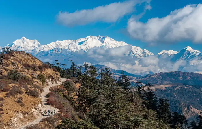
Dzongri Trek, Sikkim
The North Eastern part of India is home to many exciting and noteworthy trekking routes that attract travelers from all over the world. Among these, the Yuksom-Dzongri Trek is a particularly interesting high-altitude trail in Sikkim that is short and easily doable.
It is a smaller version of the Goechala Trek and can be completed in just five days, starting and ending in Yuksam. This trek is perfect for those who want to explore more in a limited time.
During the trek, travelers get to witness and appreciate the breathtaking beauty of the natural landscapes. The Dzongri and Dzongri La viewpoints offer the most stunning views of the Sikkim Himalayas and its towering peaks, including the world’s third highest peak, Mt. Kangchendzonga (8585 meters).
The trek features several famous and breathtaking waterfalls, as well as sunset points like Tiger Hill in Darjeeling, which add to the charm of this trek. It provides opportunities to see the majestic mountain peaks and distant valleys.
The trek is classified as moderate, and temperatures can drop below freezing at any time of the year. This extraordinary trek takes you through the dense and unspoiled forests of the Sikkim Himalayas to the Dzongri Top, which is about 15,000 feet high and offers a spectacular view of Kanchenjunga National Park.
- How to reach Dzongri Trek? Dzongri Trek is a popular trekking route in the Indian state of Sikkim. The nearest airport to Dzongri is Bagdogra Airport in West Bengal. From the airport, you can hire a taxi or take a bus to reach Gangtok, which is the capital city of Sikkim. From Gangtok, you can take a shared jeep or taxi to Yuksom.
- What is Dzongri Trek famous for? Nestled in the fabulous Himalayas, this destination offers many spectacular and charming views of the nature’s exquisiteness.
- Best time to visit Dzongri Trek: The best season for trekking in this region is the summer between mid of March till June mid and then during mid September till November.
- What is the height of Dzongri Trek? 4250 meters
- What is the length of Dzongri Trek? 10 km
- How difficult is Dzongri Trek? Dzongri trek is one of the most difficult treks in India.
Check Stay Options At
Trekking Places In South India
Chokramudi Trek, Kerala
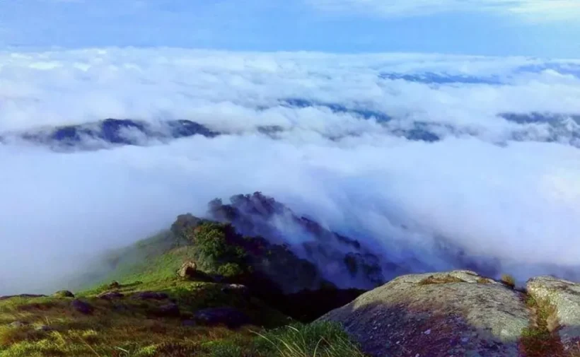
Chokramudi Peak, situated between Bison Valley and Munnar in Kerala, is one of the highest peaks in Munnar and is considered in top 10 trekking places in South India .
Located at a height of approximately 7,200 feet within the Eravikulam National Park, the peak is separated from other hill ranges, but offers a spectacular view of the surrounding valleys, mountains, dense forests, and lush green tea plantations.
The nearby Anamudi Peak and Idukki Dam can also be viewed from the top. As it is located within the national park, the hill is covered with evergreen Shola forests and is home to various species of wildlife, including Nilgiri Tahrs, Gaurs, and Asian Elephants.
There are well-defined trekking trails that lead to the top. The initial climb is easy and then the path becomes rocky until the first peak, Kurisumala. Beyond that, Chokramudi is a little tougher to reach and the terrain can become more challenging towards the end.
However, the destination is worth the effort, as the trek offers the opportunity to spot a variety of flora and fauna along the way making it a strong contender in our list of top 10 trekking places in India.
- How to reach Chokramudi Trek? The nearest airport to Chokramudi is Cochin International Airport. From the airport, you can hire a taxi or take a bus to Munnar, which is the nearest town to Chokramudi.
- What is Chokramudi Trek famous for? The Chokramudi Trek is famous for its scenic beauty and breathtaking views.
- Best time to visit Chokramudi Trek: You can feel the biting cold with the pleasant scenery from December to February.
- What is the height of Chokramudi Trek? 2194 meters
- What is the length of Chokramudi Trek? 9 to 40 km depending on itinerary taken.
- How difficult is Chokramudi Trek? The trek is moderate in difficulty and takes around 5 hours to complete.
This concludes our article on Top 10 Trekking Places in India. We hope you find this article useful. Make sure to like and share this article. Also, don’t forget to comment your suggestions down below.
You may also like Top 10 Highest Treks In India
FAQs (Frequently Asked Questions)
Stok Kangri, standing at 20,190 feet (6,154 m), is considered the highest summit that can be trekked in India. It is also the highest peak in the Stok Range of the Himalayas in the Ladakh region of North India, making it a prominent mountain in the area. Many also recognize it as the highest trek that can be undertaken in India.
India boasts a diverse range of trekking routes, including but not limited to Ladakh, Nandi Hills, Manali, Munnar, Matheran, Nainital, Kasol, Coorg, Chikmagalur, Kasauli, Leh, Cherrapunji, Shillong, Paro, Lansdowne, Dalhousie, Coonoor, Yercaud, Wayanad, and Mahabaleshwar.
The Valley of Flowers (VoF) is an awe-inspiring trekking destination and a prominent attraction of the Garhwal region in the Himalayan state of Uttarakhand, situated about 500 km to the northeast of Delhi. Renowned for its picturesque valleys, pristine water streams, and rare and vibrant plant and animal life, the Valley of Flowers is a natural wonder that never fails to captivate visitors.
Sikkim offers some of the best trekking opportunities in India, with the 5-day Dzongri trek being a popular choice for its easy to moderate difficulty levels. This trek is considered one of the best winter treks in India, beginning and ending in Yuksom, and spanning a distance of 21 km with a maximum altitude of 15,000 feet.
Here are some of the toughest treks in India:
1. Goecha La Trek
2. Markha Valley Trek
3. Rupin Pass Trek, Dehradun
4. Auden’s Col, Gangotri
5. Lamkhaga Trek
6. Nanda Devi Base Camp
7. Snow Leopard Trek
8. Kalindi Khal Trek
The highest mountain peak in India is Kanchenjunga, towering over 8.5 thousand meters above sea level. Located on the border of Nepal and India, Kanchenjunga comprises five peaks. The next highest peak is Nanda Devi, which stands at approximately 7.8 thousand meters.
Following are the top 10 trekking places in India:
1. Markha Valley Trek, Kashmir
2. Roopkund Trek, Uttarakhand
3. Hampta Pass Trek, Himachal Pradesh
4. Beas Kund Trek, Himachal Pradesh
5. Valley of Flowers Trek, Uttarakhand
6. Rupin Pass Trek, Uttarakhand
7. Rajmachi Trek, Maharashtra
8. Sandakphu Trek, West Bengal
9. Dzongri Trek, Sikkim
10. Chokramudi Trek, Kerala
The top 10 trekking places in India ranges in difficulty from moderate to difficult.